Application Description
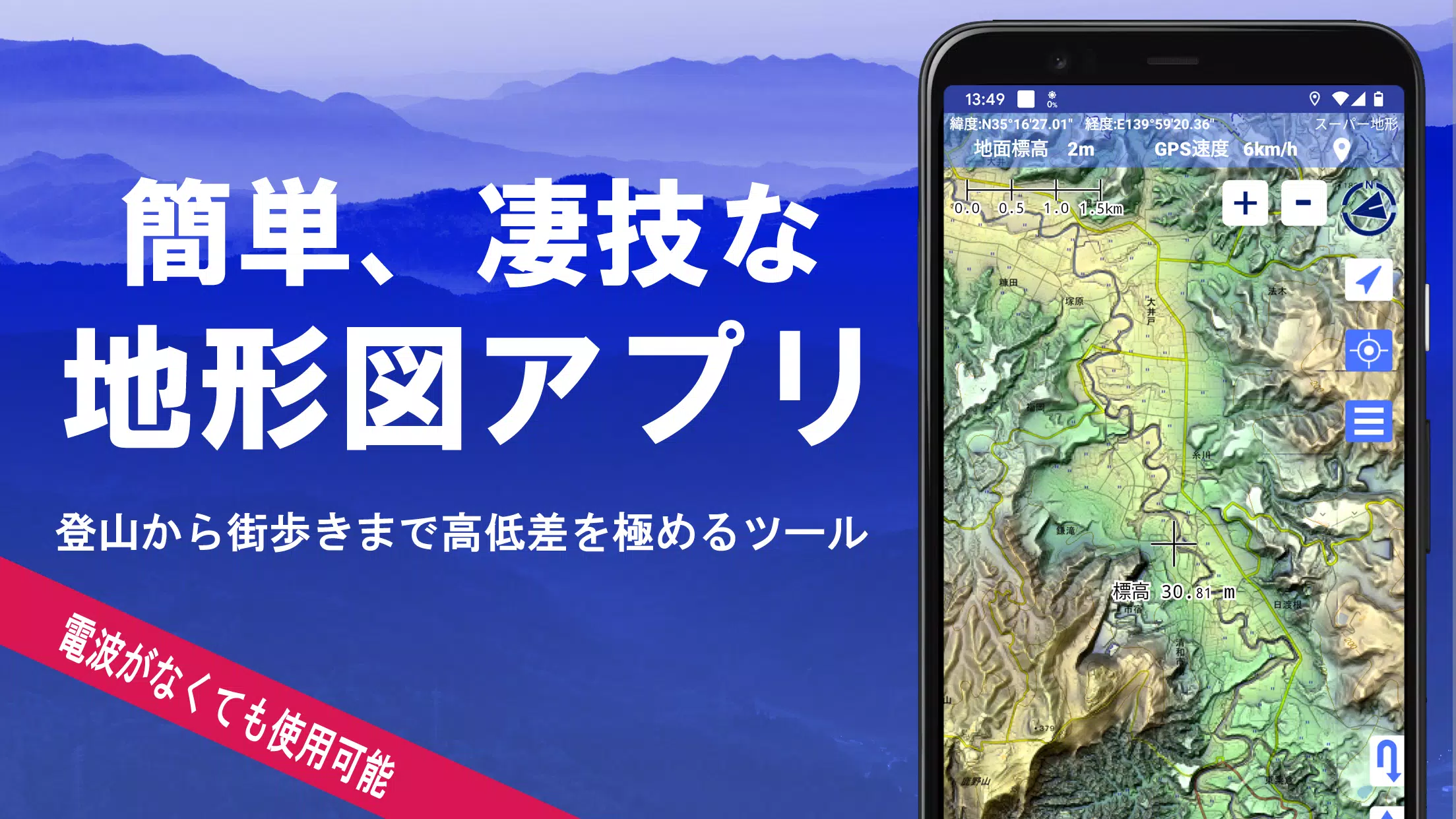
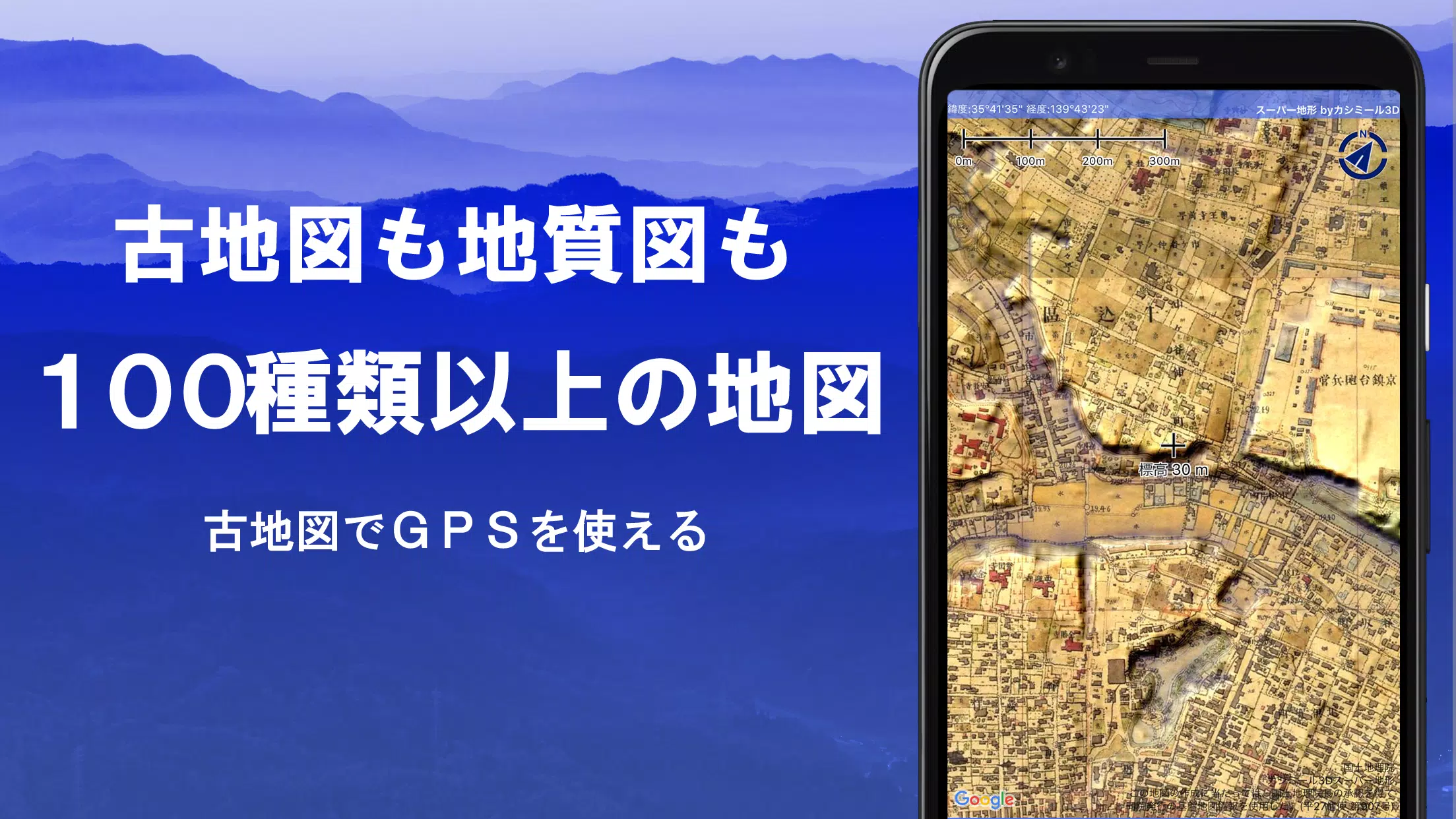
Discover the versatility of over 100 types of maps, including the renowned Geographical Survey Institute map, designed to enhance your experience from mountain climbing to urban exploration. These maps leverage height differences to their fullest, ensuring you have the best possible guidance wherever you go.
Super Terrain's excellence was recognized with the prestigious 2018 Japan Cartographic Society Award for Best Work, highlighting our commitment to quality and innovation.
- Utilize "super terrain data" that accentuates the terrain using our unique technology.
- Access an array of maps from the Geospatial Information Authority of Japan, including topographic, geological, old, past and present, and prewar topographic maps.
- Record your tracks using the GPS function, with capabilities for GPX log input, output, and editing.
- Enjoy a suite of features tailored for urban walking, mountain climbing, and outdoor activities, including GPS navigation with audio and data recording and editing tools.
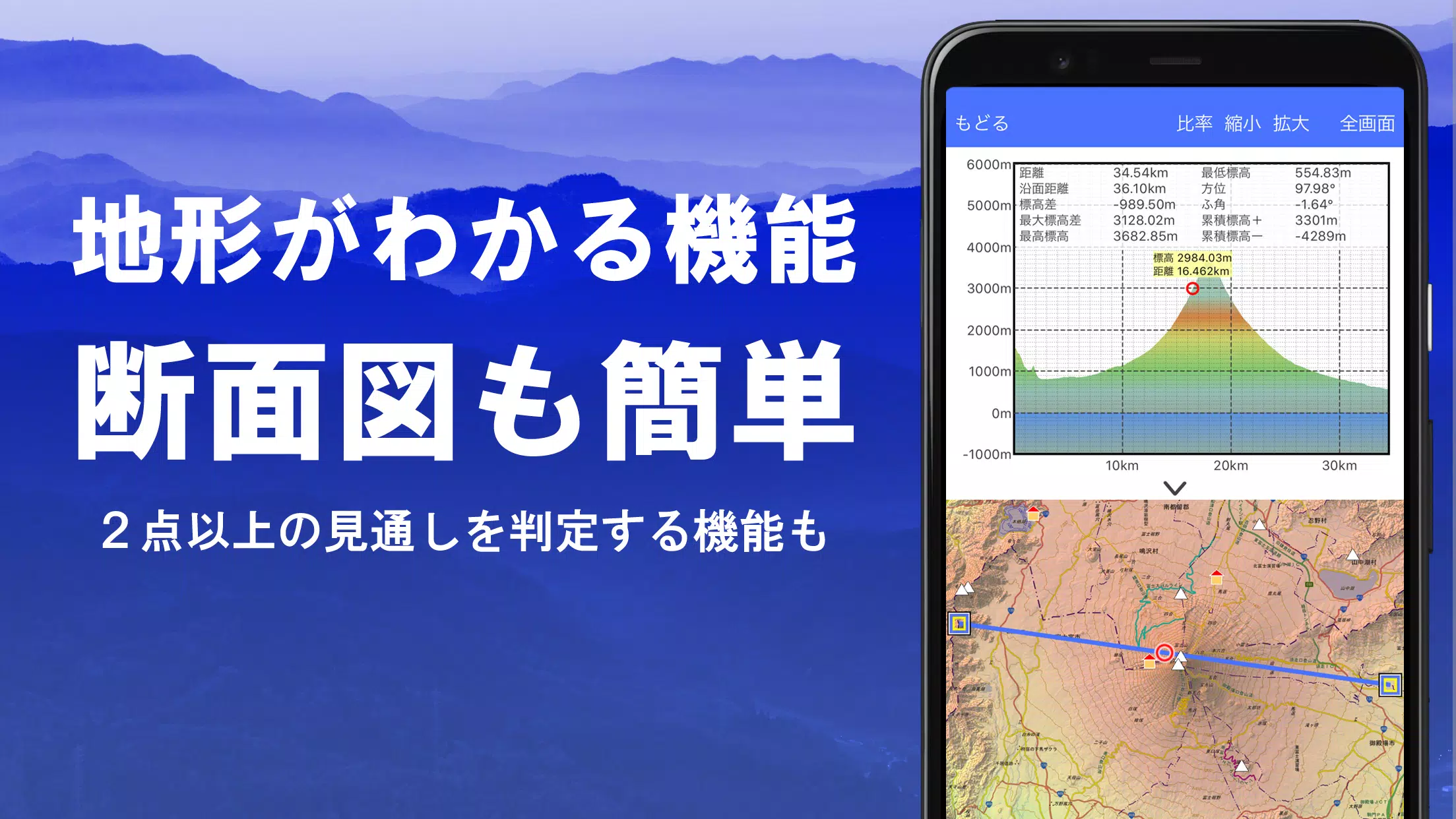
- Benefit from a visibility determination function for creating cross-sectional diagrams, aiding observation and radio communication, and even displaying buildings.
- Experience a 360° panoramic view function to identify mountains, along with the ability to display the sun, moon, and GPS points.
- Use the GPS function, bulk map download, and map cache to enjoy offline capabilities in areas without radio signals.
- Associate photos with specific points for a more personalized experience.
- View contour lines generated from elevation data for a better understanding of the terrain.
- Display the MGRS grid (UTM grid) for precise navigation.
- Read, display, and edit GIS data from GeoJSON files for comprehensive geographic information management.
- Draw shapes directly on the maps to plan routes or highlight areas of interest.
- Use the app overseas with the same level of functionality as at home.
- Print maps or output them as PDFs for sharing or personal records.
- Enjoy the convenience of a dark theme for better visibility in low-light conditions.
A Wealth of Maps at Your Fingertips
With over 100 types of maps available, including combinations, you'll find everything from our proprietary super topographic data to maps from the Geospatial Information Authority of Japan and hazard maps. Note that aerial photographs may not be available in all age groups, with "Latest" and "around 1974" offering the broadest coverage. Enjoy free access to maps using super terrain data for the first 5 days after installing the app.
Creating Cross-Sections and Outlooks
Effortlessly draw cross-sections through any point on the map, and utilize the visibility judgment function from Kashmir 3D to account for Earth's curvature and atmospheric differences. This feature is invaluable for route planning during climbs, assessing wireless visibility, and understanding terrain. Where PLATEAU building data is available, you can even include buildings in your cross-sectional views.
Elevation Palette Function
With the elevation palette function, you can customize the map's background color in 1cm increments, allowing you to tailor your visual experience to your preferences.
Panoramic View
Access panoramic observation maps to identify mountains from any location. Our 360° panorama can be linked to your smartphone's compass, making mountain identification a breeze. View the sun and moon, including moon phases, to explore phenomena like Diamond Fuji and Pearl Fuji, and locate GPS points. This feature extends to drawing panoramic views of mountains abroad.
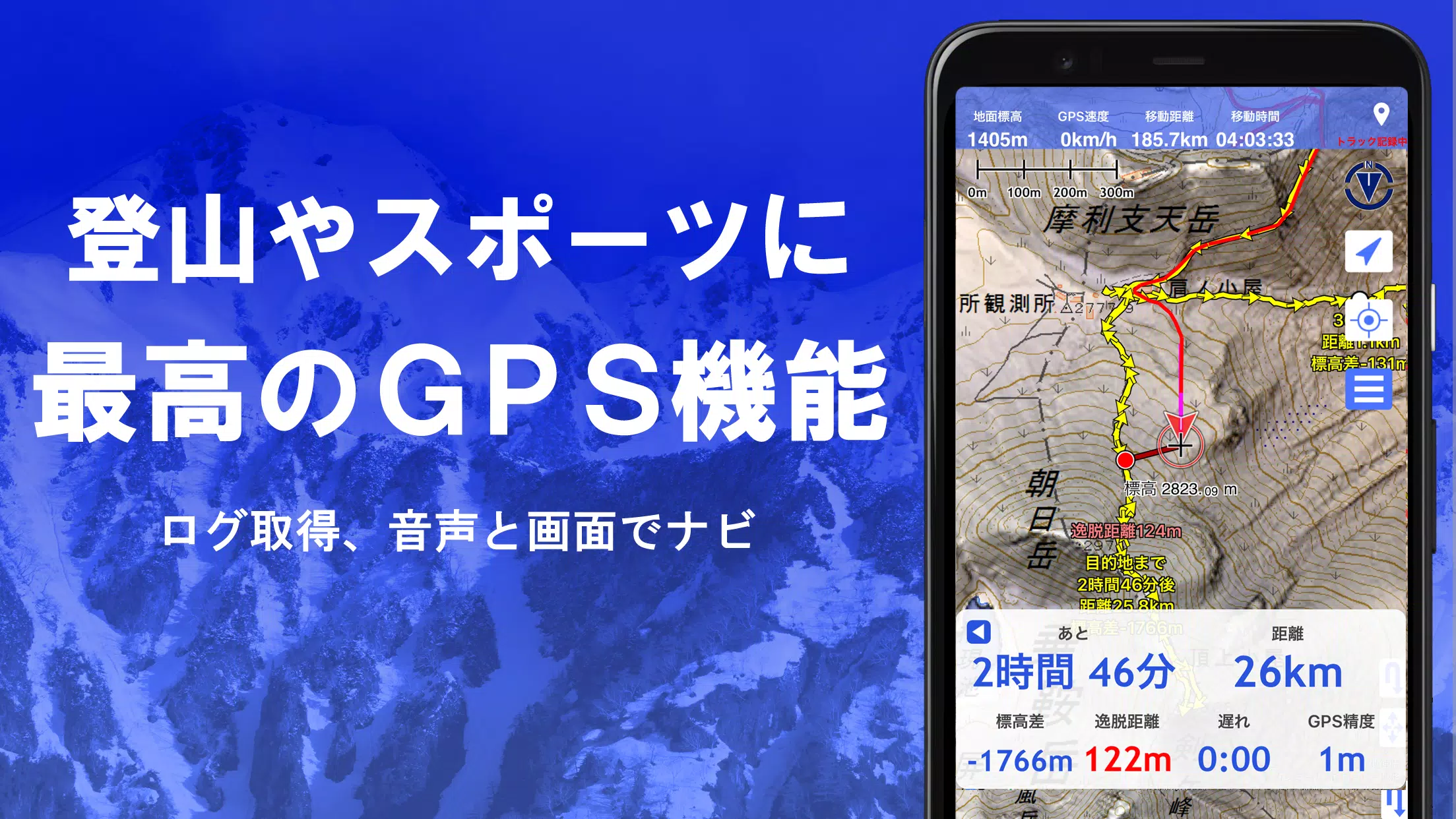
GPS Function
Leverage your smartphone's GPS to obtain location information and record tracks with high-precision position measurement, ideal for serious mountain climbing and outdoor activities. Display recorded tracks with detailed parameters like elevation change, speed, time, and elapsed time. The point alarm function notifies you with voice and alarm sounds as you approach designated points. Display photos associated with specific points and send the map center position to NaviCon.
GPS Track Summary Playback
Replay your track logs in their entirety, with the app automatically displaying photos that match the recording times. Tap on the photo icon at the location to view the images.
GPS Navigation Function
Navigate along preset tracks with the Track Navi function, receiving voice or alarm alerts if you deviate from your route, ensuring you never get lost during your climbs. Additionally, utilize route navigation for urban exploration and point navigation for targeting specific locations.
GPS Data Editing Function
Manage GPS-related points, routes, and tracks, organizing them into folders for easy navigation. Create tracks directly on the map, and import or export data in GPX format from mountain climbing sites.
Map Usage Outside the Service Area (Offline)
Continue using maps even in areas without signals, thanks to the bulk download function that lets you download all scale maps for a specified plot. Monitor what's being downloaded to ensure you're never without a map on site. A cache function is also available for enhanced offline use.
Map History Function
The app remembers previously viewed locations, allowing you to return to them with ease.
Custom Map Compatibility
Import and use custom maps cut out with Kashmir 3D's map cutter, displaying your own maps and scanned maps. When using the map cutter, divide each image into approximately 256 x 256 pixels and send the created kmz file to Super Terrain via email or Cloud Drive.
GeoJSON Compatibility
Display and edit points, linestrings, and polygons from GeoJSON format files, and draw new shapes for a more interactive mapping experience.
Print/PDF Output
Print any area of the map at a specified scale or create a PDF for sharing or personal records.
Cooperation with Other Apps
Input and output GPS data in GPX, KML, and GDB formats, enabling data exchange with other apps, the Kashmir 3D software on your PC, and trajectory data from mountain climbing sites.
Backup Function
Backup all app data (excluding cached maps) and remove it from your smartphone, with the option to restore if you delete the app or encounter a device malfunction. An automatic backup feature using Google Drive ensures your data is always up to date. Refer to the manual for more details.
About the Billing Function
Certain features, including maps using super terrain data, GPS track functions, and cross-sectional views, require in-app purchases. After payment, the number of search results for place name searches increases.
- Fees: Annual payment of 780 yen/year.
- Free Trial: Enjoy a 5-day free trial upon first installing the app. Some features and maps will become unavailable after the trial period unless you make a purchase.
- Confirmation and Cancellation: Check or cancel automatic updates via Google Play under "Regular Purchase" and select "Super Terrain."
- Price Revision: Prices may be revised with future feature enhancements, making early purchase advantageous.
Terms of Use
The copyright holder and developer are not responsible for any outcomes from using this application. Upon first use of GPS, allow location services when prompted. Be aware that continuous GPS use will drain your battery, so carry a spare if your device is used for emergency communication. An easy-to-understand explanation of the navigation function is available in PDF format at https://www.kashmir3d.com/online/superdemapp/superdem_navi.pdf. Note that some smartphones may experience interruptions when recording tracks due to power-saving features forcibly closing background apps, and turning off the screen may temporarily maintain recording, but this isn't a permanent solution.
Maps & Navigation

 Apps like スーパー地形 - GPS対応地形図アプリ